


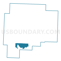
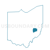
PRECINCT VALLEY A, Guernsey County, Ohio
About
Outline

Summary
| Unique Area Identifier | 646909 |
| Name | PRECINCT VALLEY A |
| County | Guernsey County |
| State | Ohio |
| Area (square miles) | 10.45 |
| Land Area (square miles) | 10.45 |
| Water Area (square miles) | 0.00 |
| % of Land Area | 100.00 |
| % of Water Area | 0.00 |
| Latitude of the Internal Point | 39.92758030 |
| Longtitude of the Internal Point | -81.55673900 |
Maps

Graphs
Select a template below for downloading or customizing gragh for PRECINCT VALLEY A, Guernsey County, Ohio


Neighbors
Neighoring Voting District (by Name) Neighboring Voting District on the Map
- PRECINCT CUMBERLAND/SPENCER, Guernsey County, OH
- PRECINCT JACKSON A, Guernsey County, OH
- PRECINCT JACKSON B, Guernsey County, OH
- PRECINCT PLEASANT CITY/VALLEY B, Guernsey County, OH
- PRECINCT RICHLAND, Guernsey County, OH
Top 10 Neighboring County Subdivision (by Population) Neighboring County Subdivision on the Map
- Jackson township, Guernsey County, OH (5,220)
- Valley township, Guernsey County, OH (2,263)
- Richland township, Guernsey County, OH (2,082)
- Spencer township, Guernsey County, OH (1,071)
Top 10 Neighboring Place (by Population) Neighboring Place on the Map
Top 10 Neighboring Unified School District (by Population) Neighboring Unified School District on the Map
Top 10 Neighboring State Legislative District Lower Chamber (by Population) Neighboring State Legislative District Lower Chamber on the Map
Top 10 Neighboring State Legislative District Upper Chamber (by Population) Neighboring State Legislative District Upper Chamber on the Map
Top 10 Neighboring 111th Congressional District (by Population) Neighboring 111th Congressional District on the Map
Top 10 Neighboring Census Tract (by Population) Neighboring Census Tract on the Map
- Census Tract 9779, Guernsey County, OH (4,515)
- Census Tract 9780, Guernsey County, OH (4,457)
- Census Tract 9778, Guernsey County, OH (4,008)
Top 10 Neighboring 5-Digit ZIP Code Tabulation Area (by Population) Neighboring 5-Digit ZIP Code Tabulation Area on the Map
- 43725, OH (20,357)
- 43723, OH (4,984)
- 43780, OH (2,106)
- 43772, OH (1,879)
- 43732, OH (1,703)
- 43722, OH (420)
- 43733, OH (95)